Tag Archives: geotechnical information

Geotechpedia reached a 1000 links on Geotechnical Software Applications!

Since 2012 Geotechpedia’s database is continually growing of geotechnical engineering information, including links for free geotechnical paper and publications, links for geotechnical equipment, hardware and heavy duty machinery, links for geotechnical software applications etc.

Geotechpedia team is now pleased to announce that a thousand links on Geotechnical Software Applications have been registered!

Each software is presented in Geotechpedia with its title, publisher, price, a small description summary, perhaps a photo or a video, tags and of course the link. There is a variety of categories i.e. Geology Software, Geotechnical Design Software, Mining, Structural etc.

Geotechpedia’s database includes catalogued free downloadable Geotechnical Paper and Publications and links for Geotechnical Equipment and Hardware.

This makes Geotechpedia an essential tool for those interested in geotechnical engineering. Since our goal is to constantly improve our quality of service, feel free to contact us for any comments or suggestions at https://geotechpedia.com/About/Contact


Geotechpedia: A geotechnical portal that is constantly evolving!

Greetings to all Geotechpedia’s fans!

First I would like to thank all of you for making Geotechpedia one of the most popular sites on the online world of geotechnical engineering. We have our google analytics reports continuously improving to prove that!

Your ideas and needs led us to add new sections in our site such as geotechnical links. In this category many relevant links can be found categorized as Geotechnical associations, organizations, forums, blogs etc. geotech_icons_links_100x100Considering that the internet world changes daily, we continue to evolve this portal adjusting to all new trends.

As many of you probably have already observed there is also a Geotechnical News category, updated daily. News around the world concerning geotechnical and geological subjects are always popping up! geotech_icons_NEWS_100x100In some cases things are hopeful and innovative such as construction news, advanced knowledge, awards, contests and conferences and in others, natural hazards and disasters test our human limits as engineers and scientists. Geotechpedia makes an effort to daily categorize the most interesting news providing you with the latest knowledge.

Another fact is that we live in a mobile technology era. Keeping in mind that a great number of people use their mobile devices to search and stay informed, Geotechpedia is now optimized as a mobile friendly geotechnical portal.

Mobile design Geotechpedia

Last but not least there is now advertising space available on Geotechpedia to all relevant companies that want to reach a worldwide geotechnical audience. Software, equipment and construction company banners and links can be prominently displayed. We created a user friendly ad platform, since you can place your ad easily in 3 steps and also you can track your ad’s visibility with real time click and impressions reports.

placeAdBanner

It is interesting to observe that the majority of people surfing in Geotechpedia are coming from countries well advanced in geotechnical engineering such as US, UK, Canada, Australia, Germany and Italy, but also from countries that nowadays manifest an impressive development in geotechnical engineering works such as India, Brazil, Indonesia, Turkey and China (source: google analytics). Another impressive feature is that Geotechpedia users browse through many pages of the site, staying engaged for a long time.

This shows that you find us interesting!

Considering that Geotechpedia project runs parallel to our geotechnical design work, your great response encourages us to keep going!

Thank you!

Is geotechnical monitoring important?

The March / April Geo-Strata was almost entirely dedicated to the GAM (Geotechnical Asset Management) for transportation systems. It was very interesting to see how this concept is evolving in the broader field of Geotechnical Engineering and transportation infrastructures.

This Geo-Strata feature is worth reading if you are interested in the future of Asset management in relation to infrastructure projects and geotechnical involvement.

I would like to focus a bit on the issue of geotechnical monitoring. As Thompson et al (GeoStrata, 2014) very elegantly observe, we have all sorts of sensors and warning lights in our cars, which enable both us and the car dealer technicians to identify a future problem as early as possible. If treated early, this problem can be resolved at a minimum cost. If left untreated, however, it could cost us our very life or even other people’s lives should a terrible car accident occur.

Car engine sensors, or airplane sensors or even elevator sensors are mandatory and nobody really argues over whether they should be installed or not. Nobody goes to a car dealership and tries to reduce the vehicle price by arguing that he does not really need the engine sensors because he can visually check his engine once in a while…

Can you imagine an airplane company, saying that in order to reduce operating costs it will remove the black boxes?

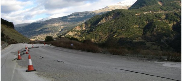
So why is it so easy to eliminate geotechnical monitoring instruments from geotechnical projects or so difficult to persuade the owners of the importance of the use of such instruments and information?  I am sure that there is not even a single geotechnical engineer who does not have examples of struggling to enforce the use of some type of

Geotechnical Monitoring

instrument and the client arguing over its cost of installation, cost of operation or even the usefulness of such geotechnical monitoring  and instruments for the project. Even worse this argument is sometimes thrown back at the designers through a challenge such as “why should we monitor the wall? Haven’t you designed it to be safe?”

Airlines and government boards do not consider installing black boxes only in planes that are old and with mechanical problems that may have a high risk of falling out of the sky. Imagine if such practices were taking place, would our planes be as safe as they are? Would they have evolved in the way they have?

Why is it so hard to do the same in geotechnical projects? Why is geotechnical monitoring and instrument installation, warranted in critical situations, on critical structures but not on ordinary slopes or embankments etc? How is the profession going to excel in future projects when real behavior of geo-structures is so difficult to find and evaluate?

As a profession, we should try to persuade owners, government officials, policy makers etc of the significance of reliable geotechnical monitoring systems included in the majority of geotechnical works. By doing this  future works and infrastructure will become safer and costs will fall far more than we may realize. Don’t put a price tag in current projects without considering future projects…

Geotechnical engineering standard of care

November – December issue of Geo-Strata which is a published forum of the Geo-Institute of the American Society of Civil Engineers (ASCE) featured an article by Patrick C. Lucia, Chairman Emeritus of Geosyntec Consultants, titled “As I See It: Geotechnical Forensic Engineering in Defense of Geotechnical Engineers”.
In the article Patrick shares his over 25 years of experience in forensic geotechnical investigation of failures and the compliance of Geotechnical Engineers to “Standard of Care”. In his opinion the majority of failures occur due to “lack of process in conducting the geotechnical engineering practice”.


Unfortunately it is very difficult to standardize geotechnical engineering practice in a way that other engineering disciplines have. The difficulty of standardizing geotechnical practice is that ground is not standard. This is why geotechnical engineering is so challenging. How can you standardize an investigation in a new project? Is the text book “influence zone” depth an adequate depth to drill? Can a few centimeters thick unfavorable clay seam be found with two 30m borings in a proposed cut? Can an undisturbed or even remolded sample be acquired from that seam? Can we pursue the client to spend additional thousands of dollars when we are unsure of what lies beneath?
Pat is arguing that “when the process of engineering is properly done and properly documented, it will far reduce the number of claims and make the defense of those claims much easier.” This is true but maybe difficult, especially in a world of fast track projects and low bids. Maybe our profession needs to do much more to “standardize” proper engineering process. Firms may need to take action to “educate” potential clients and owners about the importance of a sound geotechnical investigation, peer reviewed process in ground properties evaluation and design and necessary time that is needed.
Time is a fundamental problem in geotechnical engineering profession. It is not easily understood why maybe a month is needed for a simple foundation investigation. How can you argue when you hear “we do not have such time, we need the results in a week!”, as if we control the permeability characteristics of a clay in a consolidation test!!!
These and many other issues make our profession so challenging, difficult but at the same time so rewarding, from a scientific point of view (I don’t know any billionaire geotechnical engineer). We need to practice geotechnical engineering and at the same time educate the rest of involved disciplines in its difficulties. Unfortunately probably we are not doing very well in the second part of educating…

Geosysta welcomes 2014

Geotechpedia 2014

Geotechpedia enters 2014 with the ambition to provide more geotechnical information and contribute to the geosociety with interesting and valuable publication links, software from the industry and equipment used in the sector.

Geotechpedia now has an updated look and feel more appropriate for today’s web. We hope we can make your experience more efficient and pleasurable at the same time while we save you precious time when searching for geotechnical information.


Register with Geotechpedia, and become a member of it’s online geotechnical community. It is very easy and safe, since it uses open ID. Geotechpedia does not request that you create yet one more password and will not store any.


By Registering you can rate all geotechnical information items provided in the site, you can review papers, software or equipment and you can add items in your favorite section.

Geotechpedia registered users page

Help others with your knowledge to get faster incite in our provided geotechnical information. Access your favorite items, review etc just by clicking on your user name in the top of the page

Geotechpedia and Geosysta wish you all a happy and productive new year.

Geosysta welcomes 2014

IAEG XII Congress: Engineering Geology

IAEG XII congressIAEG (International  Association for Engineering Geology) organizes the XII Congress that will be held in Torino (Italy) from 15 to 19 September, 2014. The topic of the IAEG XII Congress is: “Engineering Geology for Society and Territory” and aims to explore and analyze the role of Engineering Geology.


There are four main themes offered to participants:

  1. Environment: River Basins, Reservoir Sedimentation and Water Resources
  2. Processes: Landslide Processes, Marine and Coastal Processes,
  3. Issues: Urban Geology and Landscapes Exploitation, Preservation of Cultural Heritage
  4. Approaches: Applied Geology for major Engineering Projects, Education Professional ethics and Public Recognition of Engineering Geology

Deadline for abstract submission is fast approaching : 15/04/2013, while the estimated Deadline for Full Paper submission is September 30, 2013.

Geotechpedia reached over 3000 free publication links on geotechnical engineering!

Our database is a continually growing database of assorted geotechnical engineering information. Everyone interested in geotechnical engineering i.e. students, professionals, academics, can browse in geotechpedia’s free publications.

Taking into account the demands of geotechnical engineering, updating information is the crucial goal for us. We are proving this by continually increasing the number of free publication links.

fireworks-

Geotechpedia team is now pleased to announce that the number of free publication links that disseminate geotechnical knowledge is over 3000!

This means that Geotechpedia has cataloged over 3000 geotechnical publications in the database, including published papers, manuals, reports, dissertations etc.


Each publication is presented in Geotechpedia with its title, author, author’s organization, location, publication type, publication reference, tags, a small description summary and of course the link.

In our effort to provide professionals in geotechnical engineering with everything they need, the database includes catalogued geotechnical software and also geotechnical equipment.

Geotechpedia is the most integral and extensive geotechnical tool on line for everyone interested in geotechnical engineering! We will be happy to receiving your feedback concerning this project. Feel free to contact us and leave your comments!

Geotechnical information versus knowledge

Francis Bacon once said that knowledge is power, these words have a profound meaning but in our days where vast amount of information is available we may want to reevaluate them. Is the vast information providing knowledge or distorts it?
In our days every question one has, he just needs to type it to a search engine and in milliseconds he will find one or multiple answers. Are any of these answers correct? Is the one asking the question qualified to evaluate the answers? Will he use any answer and then find out that he has mistakenly approached a subject? Think before you use is a good advice!
This is a very difficult subject for discussion, even philosophical one can say, but the issue is that we need to pay attention to the way information is used and evolved into knowledge. We think that information should be vastly available and easily comparable in order to produce appropriate conditions for knowledge. We want to produce such a platform where geotechnical information will be provided but at the same time it could be critically evaluated from the users and in the end rated for the benefit of knowledge.

We will try hard for that…