
In our first ever post in Geotechpedia’s blog we tried to answer the most common question among professionals in the Geotechnical engineering industry “Geotechnical Investigation data, always not enough?”. In the specific post, it has been mentioned that “some of us proudly state “I saved so much by reducing the geotechnical investigation” but all this immediately changes when something goes wrong”. We are all aware of how limited or inadequate Geotechnical Investigation (GI) can affect both a project’s schedule and budget. In the following lines, we are trying to quantify these effects, provide guidance on how to easily create a risk scoring matrix and attributed risks, typical geotechnical risks and related mitigation measures.
Cost and time effect
Back in 1748 Benjamin Franklin stated “Time is money” in his “Advice to a Young Tradesman”. This quote finds application in all business sectors and the engineering one couldn’t stand out as an exception. In every project, delays are translated into cost and as such we are going to examine the estimated cost effects of delays deriving from inadequate Geotechnical Investigation on a project’s total construction budget. The most common chart when discussing the risk management in geotechnical engineering is presented below (Figure 1). It is obvious that for low values (1% approximately) of Geotechnical Investigation cost / tender cost (adjusted values), the total increase in construction cost may vary between 2% and 98% with an average value of 15-25%. When the Geotechnical investigation budget is slightly increased (adjusted Geotechnical Investigation cost / construction tender cost values between 2 and 4%) then the total increase in the construction cost drops to a typical range of 2% to 25% with an average value of 5-10%; meaning that an increase of 1-2% on the construction tender cost for additional Geotechnical Investigation signalizes a significant drop of approximately 25 to 50% (absolute values) in the total construction cost.
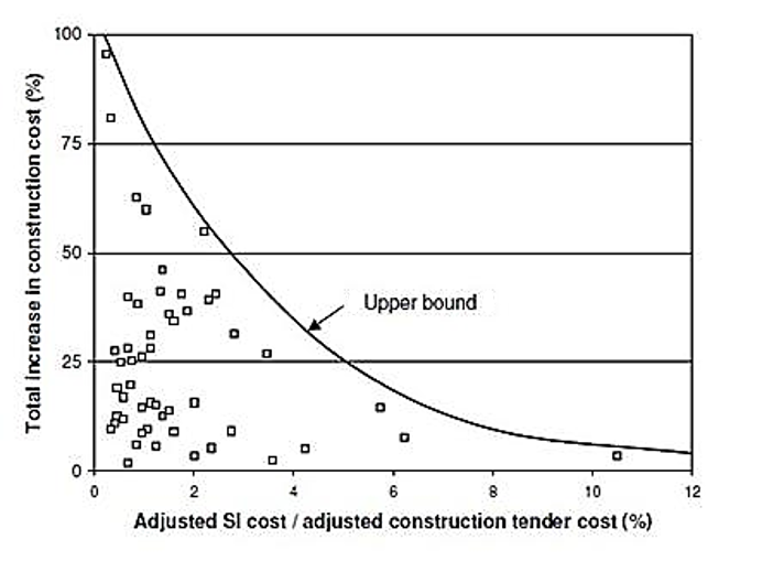
Figure 1: Total increase in construction cost related to adjusted Geotechnical Investigation cost / construction tender cost (source: UK Highways Agency projects (1994))
Typical Risk Scoring Matrix
During the tendering procedure of a project, a risk assessment needs to be undertaken in order to evaluate the geotechnical risks at an early stage and propose mitigation measures. The following table (Table 1) presents a typical and simple scoring matrix that can be used in this kind of assessments and Table 2 details the specific risks associated with geotechnical works and categorizes them into probability of occurrence and cost/time impact.
The purpose of the following matrix is to help rank the key risks on site.
Table 1 Risk scoring matrix
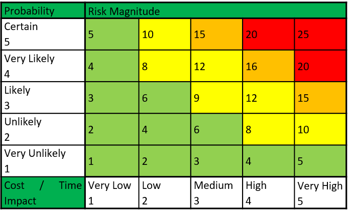
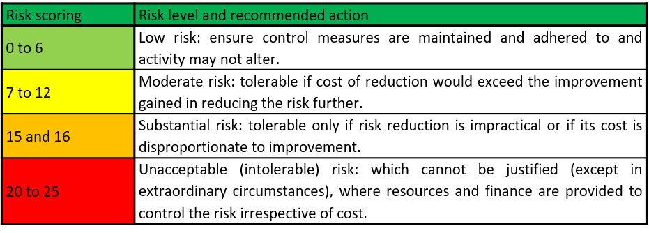
Scores of 1-5 are allocated to the probability and impact in order to quantify and rate the risk rating. The risk scoring matrix should be used in conjunction with the priority action table detailed below (Table 2).
Table 2 Priority action table
Typical Geotechnical Hazards and recommended mitigation measures
Successful implementation of the suggested mitigation measures will assist with managing and reducing known risks to acceptable levels.
Table 3 below presents typical risks/hazards, related impact on construction budget and proposed mitigation measures.
Table 3 Risk/hazard assessment and proposed mitigation measures

In general, Geotechnical Risk Management gains supporters through the Projects Manager’s community since experience has proved that inadequate or incomplete Geotechnical Investigation during the tendering stage can have a severe impact on a project’s schedule and overall cost. Moreover, managing geotechnical risks also helps to increase safety levels in siteworks.
Conclusions
We need to keep in mind that geotechnical risk cannot be avoided and ignored but it can be managed and mitigated.
Taking all the above into consideration it is recommended that a detailed Geotechnical Investigation program is proposed at early stages of each project, following an in-depth desk study of all available information and site walk-over surveys.
It must be highlighted that the above post and its recommendations are to be read in conjunction with site specific available information and with critical thinking. In all cases, the Designer should set strict guidance for adequate Geotechnical Investigation in line with project specifications and international standards.
Useful References
[1] BS5930:1999, British Standard Code of practice for Site Investigations
[2] EuroCode 7 – IS EN 1997-2:1997 (Part 2, Annex B3)
[3] Clayton, C.R.I. (2001) Managing geotechnical risk, Thomas Telford.