All posts by Elina Apostolou

About Elina Apostolou

Elina Apostolou is an Engineering Geologist. She received her bachelor degree in Geology from National and Kapodistrian University of Athens in 2002, graduating from the Department of Dynamic, Tectonic & Applied Geology and specializing in Structural Geology and Geological Cartography. She received her master’s degree from Imperial College London in 2003, Department of Civil and Environmental Engineering specializing in “Engineering Geology”. She worked as an Engineering geologist at Geodata Greece (Salonica), performing field work and composing geotechnical evaluations for various tunnel projects. For a short period of time she worked at the head office of Geodata SpA. in Turin Italy, acting as a liaison between the Greek branch and the Turin based office, considering a specific project. She worked as a geotechnical engineer – engineering geologist at General Consulting Ltd Istria for 4 years, specializing in various geotechnical engineering aspects. Her field of expertise includes geotechnical design of cut and cover tunnel portals, geotechnical evaluations of tunnels, earthworks (embankments, cuts) and structures, design of embankments and cuts, slope stability analysis, rockfall analysis and countermeasures. Meanwhile she received her second master’s degree from National Technical University of Athens in 2010, Department of Civil Engineering and Mining & Metallurgical Engineering, i.e. postgraduate award in “Design and Construction of Underground Works”.

Geosysta at 12th International Symposium on Landslides (ISL)

Training and professional development have always been integral to operations at Geosysta. It is our priority to keep our team learning new skills and maintain our strong connections with academia and professionals by always trying to share our knowledge in the fields of geotechnical and mining engineering.

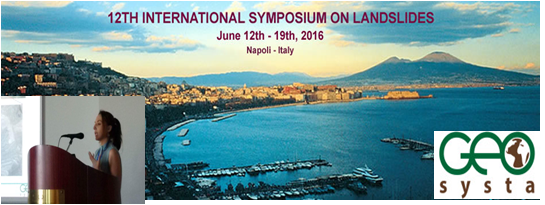
As part of our constant evolvement, Geosysta participated in the 2016 12th International Symposium on Landslides (ISL) held 12-19 June in Napoli, Italy, where well documented case histories of landslides were presented providing a better understanding of related mechanics, accounting for relevant soil and rock properties and their behaviour.

heade_new_06-05-2015

As per the conference committee: “The landslides risk has strongly increased over the last decade, mainly because of ever growing population and relevant bigger exposure. In many countries, this is also due to expanded civil and industrial settlements, as well as widened infrastructures and lifelines. For this reason, in order to perform risk analysis and management, it is necessary a better understanding of landslides’ mechanics, accounting for relevant soil and rock properties and their behaviour in well documented case histories.”

Sessions that focused on landslides development mechanisms and the findings of post geotechnical investigation, moving from experience to practice through theory, were presented during the conference. The conference’s presentations covered a wide range of both practical and theoretical approaches when investigating the reasons resulting to landslides and how their findings could be used in order to predict similar future events.

Georgia Papavgeri, Civil and Geotechnical Engineer at Geosysta, said: “Everything came together for a successful conference. It was exciting to be among so many experienced professionals being able to share Geosysta’s unique story and expertise on landslides events”.

received_881193591986049
Georgia Papavgeri at ISL 2016

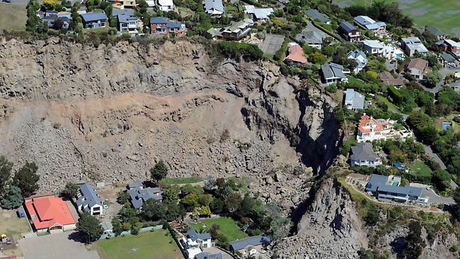
Georgia presented a 10 minutes session on “Large moving landslide inside a lignite mine in Northern Greece”. The presentation discussed an actual case inside an 170-180-meter deep lignite mine in Northern Greece, where the combination of thin clay layers, overlaying deep sandy layers with an unfavorable inclination and complex tectonic formation have resulted in a slow moving landslide. Since this is an active mine, with large earthwork moving operations, it was important to accurately evaluate the mechanisms that led to the formation of the landslide, and the effects of the moving landslide body to the operations of the mine. During the investigation of this large landslide area, different data were utilized, starting from borehole data of more than 50 borings ranging from 150-300m deep, 6 borehole in which High Resolution Acoustic Televiewer loggings where performed, and three deep inclinometers. All data were combined and critically evaluated to generate the possible landslide mechanisms and to evaluate different analysis methodologies.received_881193118652763

Another important component of ISL 2016 was the trade show and the participation of many sponsors from across Italy, Europe and around the world. During the Symposium there was the opportunity for Exhibitors, Producers and Distributors, Public and Private Societies, Contractors and Consultants to promote the name and the image of their companies to all registered participants.

20160617_160846 20160617_170022 13499661_882989831806425_1784048502_o

Geotechpedia: A geotechnical portal that is constantly evolving!

Greetings to all Geotechpedia’s fans!

First I would like to thank all of you for making Geotechpedia one of the most popular sites on the online world of geotechnical engineering. We have our google analytics reports continuously improving to prove that!

Your ideas and needs led us to add new sections in our site such as geotechnical links. In this category many relevant links can be found categorized as Geotechnical associations, organizations, forums, blogs etc. geotech_icons_links_100x100Considering that the internet world changes daily, we continue to evolve this portal adjusting to all new trends.

As many of you probably have already observed there is also a Geotechnical News category, updated daily. News around the world concerning geotechnical and geological subjects are always popping up! geotech_icons_NEWS_100x100In some cases things are hopeful and innovative such as construction news, advanced knowledge, awards, contests and conferences and in others, natural hazards and disasters test our human limits as engineers and scientists. Geotechpedia makes an effort to daily categorize the most interesting news providing you with the latest knowledge.

Another fact is that we live in a mobile technology era. Keeping in mind that a great number of people use their mobile devices to search and stay informed, Geotechpedia is now optimized as a mobile friendly geotechnical portal.

Mobile design Geotechpedia

Last but not least there is now advertising space available on Geotechpedia to all relevant companies that want to reach a worldwide geotechnical audience. Software, equipment and construction company banners and links can be prominently displayed. We created a user friendly ad platform, since you can place your ad easily in 3 steps and also you can track your ad’s visibility with real time click and impressions reports.

placeAdBanner

It is interesting to observe that the majority of people surfing in Geotechpedia are coming from countries well advanced in geotechnical engineering such as US, UK, Canada, Australia, Germany and Italy, but also from countries that nowadays manifest an impressive development in geotechnical engineering works such as India, Brazil, Indonesia, Turkey and China (source: google analytics). Another impressive feature is that Geotechpedia users browse through many pages of the site, staying engaged for a long time.

This shows that you find us interesting!

Considering that Geotechpedia project runs parallel to our geotechnical design work, your great response encourages us to keep going!

Thank you!

ISSMGE Paris 2013. What did you miss?

A brief feedback from Chrys Steiakakis

A brief summary  for all the people that could not make it to the 18th International conference on soil mechanics and geotechnical engineering held on Paris between Monday 2 and Friday 6th of September 2013. The conference main theme was “Challenges and Innovations in Geotechnics”.

The conference commenced with the former president J. L. Briaud presentation of “The State of the Society” in which a very interesting point was his 10 rules for success.

J. L. Briaud presentation of “The State of the Society”

The conference continued with the 8th Terzaghi Oration invited lecture from Susan Lacasse of the Norwegian Geotechnical Institute (NGI).

Susan Lacasse presentation “Protecting society from landslides – the role of the geotechnical engineer”

The title of the lecture was “Protecting society from landslides – the role of the geotechnical engineer”. The lecture presented case studies of landslides, their causes and the way they were analyzed and treated. Very interesting was the Kattmarka landslide that occurred on March the 13 2009 (which incidentally was Friday the 13!) and was caused because of the road construction. Main issues that led to the landslide were among others the limited geotechnical investigation and geotechnical design.

The first day continued with the Ishihara lecture presented by George Gazetas from the National Technical University of Athens (NTUA). The presentation title was “Soil-Foundation-Structure systems beyond conventional seismic failure thresholds”.

George Gazetas presentation “Soil-Foundation-Structure systems beyond conventional seismic failure thresholds”

He presented a novel approach of designing shallow foundations that are not designed to behave elastic in earthquake loading but to be able to work in extreme conditions and allow for uplift and bearing capacity slippage with acceptable limits of temporary and permanent deformations (settlements). This approach is contrary to current codes but it was shown that it could avoid structural damage and collapse.

The conference continued with the Manard Lecture presented by J. L. Briaud with title “The pressuremeter test: Expanding its use” in which he explained how to correctly utilize the PMT, how to execute the drillings and what the advantages of the pressuremeter test are. Furthermore he gave some reference values for preliminary design and some further extend of the test in liquefaction.

J. L. Briaud presentation “The pressuremeter test: Expanding its use”

A.Sim of Soletanche-Bachy provided an excellent presentation regarding the construction challenges and difficulties for the new Bugis Station and associated tunnels for the Mass Rapid Transit in Singapore.  Especially interesting were the methods used to overcome the passage of the tunnels and the station under or very near buildings.

A.Sim of Soletanche-Bachy presentation

Professor R. Jardine of Imperial Collage presented the Bishop Lecture in which he presented a state of art of laboratory testing and the use in research and practice. The lecture covered driven piles in sand and the detailed laboratory evaluation of these sands in order to predict pile behavior in static and cyclic loading.

Professor R. Jardine presentation Bishop lecture

The conference continued the next day with very interesting invited lectures that will be presented in a following entry.

Impressive fault mirror study in central Greece

Greece is a country with high seismicity rates. As a consequence evidences of faulting are spread throughout the country. In this blog a particular fault mirror has come into our notice in central Greece, Fthiotida area, known as Arkitsa fault. This spectacular fault mirror is a subvertical feature 65m tall and about 300m long. The Arkitsa fault mirror is located in an area adjacent to the famous historic Thermopylae pass (Hot Gates), which is characterized of normal tectonic features and geothermal springs known since antiquity.

arkitsa fault mirror
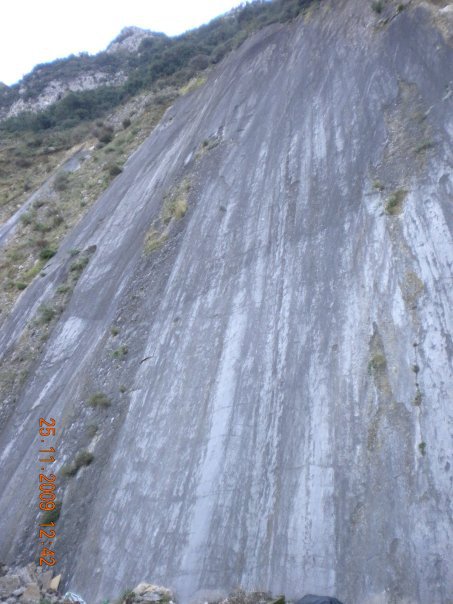
The Arkitsa fault is considered by geologists to be active even though its historic activity has not been recorded. For this reason the Department of Geology of University of Patras (Greece), with
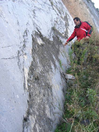
 Prof. Sotiris Kokkalas in charge, in cooperation with Durham University (UK), has initiated a study of the fault mirror of Arkitsa based on LiDAR technology. The purpose of this study is to provide a detailed geometric survey of Arkitsa fault so as to predict the magnitude of a future earthquake.

In addition a palaeoseismology analysis has been performed in order to estimate the seismic activity of the fault for the last 10.000 – 20.000 years. The analysis included collection of clay samples from the fault zone. Modern methods were used such as radiocarbon dating, scanning electron microscope and X-ray microanalysis. The palaeoseismological data indicate that Arkitsa fault has given at least four significant earthquakes the last 20.000 years. It is estimated that the last one was around 1300 – 1110 BC. In addition archaeological relics of destruction in an adjacent ancient settlement, as well as radiocarbon dating in tsunami deposits, possibly indicate this last activation of Arkitsa fault.

Arkitsa Greece fault mirrorIt is considered that the time span of significant magnitude earthquakes of Arkitsa fault is large i.e. every 3.000 to 5.000 years. As a consequence since the last one was almost 3.000 years past, nowadays we are going through a period of time likely to give a seismic reactivation of the fault. Even though the wider area is deformed slowly (1-3 mm/year), Arkitsa rupture together with the adjacent Atalanta fault, are considered to be active.

Studying the Arkitsa rupture, scientists have decreed that in case the fault is reactivated, the maximum earthquake magnitude will be 5.9 to 6.2. It should be noted that this particular fault mirror presents a complexity that deviates from planar geometry.

This study is still in progress and its results are expected with interest. Hopefully similar studies will contribute in future to the scientific area of earthquake prediction, since this matter concerns a large number of humans around the world.

Source: http://www.enet.gr/?i=news.el.episthmh-texnologia&id=371724

Sinkholes: Is it a natural or man induced hazard?

Lately the subject of sinkholes has appeared on press due to a fatal incident in Florida USA and several incidents in Samara Russia.

In the first case a man sleeping in his bedroom in Tampa Florida, disappeared when a 5 – 10m diameter sinkhole opened suddenly under his house. The estimated depth of the sinkhole was approximately 10m. Despite the authorities’ efforts the 37 year old man could not be rescued.sinkhole

 In city of Samara in Russia similar phenomena disturb everyday life. It has been reported that huge sinkholes have sprung up all over the city, in car parks, intersections and road sides, sometimes big enough for busses to disappear in them.

But why some areas like Florida are plagued by sinkholes?

Sinkholes are mostly a karstic feature along with caves and underground drainage systems. Karstic landscape is formed from the dissolution of soluble rocks such as limestones, dolomites, marble, gypsum and salt. Such karst region is Florida, presenting numerous superficial karstic features i.e. sinkholes or dolines. Florida Sinkholes

In order to understand and deal with this geologic hazard the American Geological Institute, produced an interesting booklet, explaining such phenomena.

Solution sinkholes appear when acidic water moves through the bedrock dissolving it. The underground water flow dissolves soluble rocks at or just below the water table.  This way underground water canals in bedrock are expanded and roof caves can collapse when becoming too wide to support the bedrock overlying them.

The danger of collapse increases when water table is lowered and underground caves are drained thus eliminating water buoyancy (supporting force). Usually soils overlying bedrock are forming a sinkhole when deeper soils wash into underground karstic caves. This case is the most common occurring.

Human activity such as poorly designed drainage, failed water and sewer systems and ground vibrations can lead to sinkhole formation, mainly because large amounts of surface water infiltrates in soluble bedrock. In addition dewatering activities trigger the appearance of sinkholes by rapidly lowering water tables.

IAEG XII Congress: Engineering Geology

IAEG XII congressIAEG (International  Association for Engineering Geology) organizes the XII Congress that will be held in Torino (Italy) from 15 to 19 September, 2014. The topic of the IAEG XII Congress is: “Engineering Geology for Society and Territory” and aims to explore and analyze the role of Engineering Geology.


There are four main themes offered to participants:

  1. Environment: River Basins, Reservoir Sedimentation and Water Resources
  2. Processes: Landslide Processes, Marine and Coastal Processes,
  3. Issues: Urban Geology and Landscapes Exploitation, Preservation of Cultural Heritage
  4. Approaches: Applied Geology for major Engineering Projects, Education Professional ethics and Public Recognition of Engineering Geology

Deadline for abstract submission is fast approaching : 15/04/2013, while the estimated Deadline for Full Paper submission is September 30, 2013.

Engineering Geology – Christchurch Earthquake Presentation

On February 2011 an earthquake of M=6.3 magnitude struck Christchurch in New Zealand causing the death of 185 people. This earthquake has particular significance for geotechnical engineers, since a number of geotechnical phenomena were manifested during and after the event. Liquefaction in a wide area and landslides (rockfalls), caused widespread damage across Christchurch especially in the central city and eastern suburbs.

The 22nd February 2011 Christchurch earthquake was an aftershock of the September 4th, 2010 magnitude M=7.1 earthquake that struck the western part of the city. As a consequence the buildings and infrastructures that were already weakened, were severely damaged during the Christchurch earthquake.

The Geological Society of London is hosting a presentation about Christchurch earthquake on Thursday 11 April 2013. The presentation will focus on the geological and geotechnical aspects of the earthquake and on future development of Christchurch city.

See here for more details about the event and the speakers.

christchurch-earthquake
Landslides caused by Christchurch earthquake
www.news.com.au

Mining software: new category in the database

Geotechpedia today proudly presents the new category for mining software. Mining is a highly profitable industry worldwide. For this reason several companies have developed mining related software i.e. mine stability design, 3D visualization of mines, cost estimation, underground mining, surface mining etc.

mining_software_vulcan_maptek

Geotechpedia team has worked in order to create a user friendly mining software category. The classification subcategories are the following: General, Mine management software, Surface mining software, Underground mining software. The General subcategory also includes mining software packages that deal with both surface and underground mining.

Additional information in Geotechpedia database concerning software packages is whether the license is commercial or free and whether you can try a demo version.

In order to optimize our new mining software category we welcome any comments and feedback you care to provide us!


Geotechpedia reached over 3000 free publication links on geotechnical engineering!

Our database is a continually growing database of assorted geotechnical engineering information. Everyone interested in geotechnical engineering i.e. students, professionals, academics, can browse in geotechpedia’s free publications.

Taking into account the demands of geotechnical engineering, updating information is the crucial goal for us. We are proving this by continually increasing the number of free publication links.

fireworks-

Geotechpedia team is now pleased to announce that the number of free publication links that disseminate geotechnical knowledge is over 3000!

This means that Geotechpedia has cataloged over 3000 geotechnical publications in the database, including published papers, manuals, reports, dissertations etc.


Each publication is presented in Geotechpedia with its title, author, author’s organization, location, publication type, publication reference, tags, a small description summary and of course the link.

In our effort to provide professionals in geotechnical engineering with everything they need, the database includes catalogued geotechnical software and also geotechnical equipment.

Geotechpedia is the most integral and extensive geotechnical tool on line for everyone interested in geotechnical engineering! We will be happy to receiving your feedback concerning this project. Feel free to contact us and leave your comments!