All posts by Amalia Tziovara

About Amalia Tziovara

Amalia is a Geologist with a Master in Business Administration (MBA) and more than 15 years of professional experience. She started her career as a geologist for EMVELEIA S.A. but shortly after she became a member of the Bid and Tendering Department of ADT - OMEGA S.A. and a Quality Assurance Manager. Her duties included among others: search for tenders, coordination and check of the required tender documentation, participation in the drafting of the technical offer, offer submission and monitoring the course of the tender, administrative support for contracts, handling and monitoring of quality control procedures. Amalia joined Geosysta's Geological & Geotechnical Department in 2018. Her tasks include the elaboration of geological and geotechnical designs and administrative support.

Geotechpedia reached a 1000 links on Geotechnical Software Applications!

Since 2012 Geotechpedia’s database is continually growing of geotechnical engineering information, including links for free geotechnical paper and publications, links for geotechnical equipment, hardware and heavy duty machinery, links for geotechnical software applications etc.

Geotechpedia team is now pleased to announce that a thousand links on Geotechnical Software Applications have been registered!

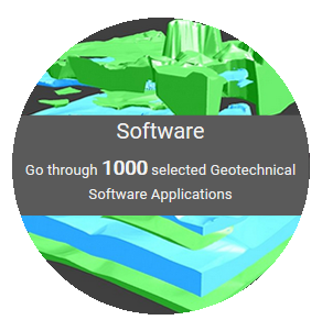
Each software is presented in Geotechpedia with its title, publisher, price, a small description summary, perhaps a photo or a video, tags and of course the link. There is a variety of categories i.e. Geology Software, Geotechnical Design Software, Mining, Structural etc.

Geotechpedia’s database includes catalogued free downloadable Geotechnical Paper and Publications and links for Geotechnical Equipment and Hardware.

This makes Geotechpedia an essential tool for those interested in geotechnical engineering. Since our goal is to constantly improve our quality of service, feel free to contact us for any comments or suggestions at https://geotechpedia.com/About/Contact


Geosysta winning the Greece Challenge for ReTiMoS landslide monitor system, in the ESNC 2018!

Geosysta participated in the European Satellite Navigation Competition (ESNC) with the idea: “Real time monitoring of slopes and landslides with low cost GNSS receivers (ReTiMoS)” and was the Regional Winner of Greece.
Geosysta’s real time, cloud-based software Minefeed produces reliable storage, evaluation and alerts for slope stability monitoring based on records captured by topographic and geotechnical instruments. Geosysta has designed a system for real-time monitoring of slopes and landslides – ReTiMoS. This system can be used by the mining sector, highway operators and local authorities without significant experience in the field of slope stability to address the safely issue of upcoming or imminent landslides.
Geosysta’s idea was also one of the top 10 and she was invited to another very exclusive event as well, the E-GNSS Accelerator Bootcamp which took place on 04 Dec in Marseille, France.
The Awards Ceremony was held on 4th of December at the Palais du Pharo in the heart of Marseille, France, before an audience of about 600 invited guests.

The award received on behalf of the whole team, Mr. Chrysanthos Steiakakis, Civil and Mining Engineer, MSc, Co – Founder and CEO of Geosysta.

Special thanks goes to the Technical University of Crete and especially to Dr. Panagiotis Partsinevelos who is also an expert of the Galileo Masters, for their guidance, contribution and expertise.


Geosysta at the 14th International Symposium of continuous surface mining

Geosysta participated in the 14th International Sumposium of continuous surface mining (ISCSM 2018), held on 23-26 September in Thessaloniki, Greece, where professionals from all over the world presented their work and discussed the latest developments on continuous surface mining.

Geosysta was one of the main sponsors of the Symposium and presented the following papers:

  1. “A cloud-based real-time slope movement monitoring system”, where a robust cloud-based data management software application which is called Minefeed was presented. This application collects, stores and analyses any type of monitoring data and is used by the Public Power Cooperation to monitor all its mine slopes. The system incorporates a vast amount of data such as target survey measurements, inclinometers, piezometers, tiltmeters etc. This geotechnical monitoring system has evolved over many years and has been successfully used for slope monitoring in large surface mines.
An overview of Minefeed

The presentation was made by Chrysanthos Steiakakis, Civil and Mining Engineer, MSc, Co – Founder and CEO of Geosysta.

  1. “A Real-Time Event-Driven Database System for Maintenance Planning and Productivity Analysis in Continuous Surface Mining Operations”: This paper presents a real-time event driven data management application, which was developed for the surface lignite mines in northern Greece by Prof. Agioutantis and his colleagues. The mines operate using a continuous mining system, utilizing bucket wheel excavators, conveyor belts, spreaders and stackers. Each mine features its own control center installation comprising of PLCs, Aspect Servers, OPC servers and a SCADA system. The data management system is installed on the network backbone and draws data from the OPC servers. Data are then modified by control tower personnel and are used to generate reports for production monitoring, equipment performance and utilization as well as maintenance tasks. The system has been operational since 2011.

Stamatini Delmadorou, Civil and Structural Engineer, MSc at Geosysta presented this data management system.