
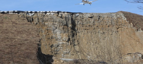

Recent news and photographs present the spectacular slide that occurred in the Yeager Airport Expansion Runway 5. The slide occurred in the South slope which was among the highest if not the highest (~74m) reinforced earth slope in the US. The project had received the award of Excellence – TenCate Geosynthetics in 2007 International Achievement Awards. According to FHWA Manual the Yeager Airport in Charleston WV had been constructed as a massive earthwork in 1940’s. The mountainous conditions around the airport produced steeply dipping slopes to the Elk and Kanawha Rivers. In order to meet FAA Safety Standards runway 5 required a 150m extension in order to create an emergency stopping apron. The most cost effective solution was a 74m high 1H:1V reinforced steepened slope (RSS). The chosen solution is presented in Figure 1 taken from Lostumbo 2010.

As can be seen from Figure 1, most of the reinforced earth area is above the original ground and only a small part in the slope base is excavated in order to found the reinforced earth structure. Based on Lostumbo, 2010 over 100 borings were performed, with extensive laboratory testing and the final outcome was that the site consisted of primarily fill, colluvial and shallow rock. The material parameters used for the bearing soil zone were unit weight γ=22kN/m3, φ’=40ο and c’=0kPa. I would like to provide some speculations regarding this incident based on the available data found on line and photographs from the news and Google earth. I must point out that these are only speculations since no official data are available to me, nor the exact design or construction plans. These speculations are made just by observations and engineering imagination! I am sure that significant investigation will take place in the coming months and years which will produce the actual conditions and reasons for this spectacular failure. A picture from Google earth taken on 9/2005 presents the initiation of excavation for the construction of the reinforced earth slope.

A newer picture taken on 4/2006 presents the progress of works in which a part of the reinforced earth slope has been constructed.

It is very interesting to note that the excavation and foundation of the earth structure did not go all the way to the base of the hill. It is possible that good foundation material (assuming rock) was found in some elevation and was considered appropriate for founding the structure. After all the large earth structure is placed on sound rock (mostly sandstone) with a compressive strength between 30-95MPa! Weathered sandstone from the borrow area had a friction angle between 38.9-39.6o. The placement of the reinforced earth structure on top of bedrock can be observed in figure 4. The bedrock is clearly visible in the back and some moisture can be observed a bit higher in the slope.
Is the “competent” foundation bedrock to blame?, is the design of the reinforced slope to blame? Is the construction practice? Is the intense rainfall? Usually many factors contribute to such a large failure, but at this point with very limited information I would like to focus on the bedrock conditions and the fill material placed on the bedrock.
.")
Is a sound bedrock always appropriate for placing such a large structure? Based on the unconfined compressive strength I would say yes, but are other conditions at play here? Based on Huang et al, 2014 “the on-site geomorphology consisted of weathered sandstone underlain by sandstone and some shale.” and “The compressive strength of the rock foundation varied from 30MPa to 95MPa. The high bearing capacity of the underlying sandstone foundation and the high friction angle of the onsite weathered sandstone soil meant that the extent of the reinforced slope could be kept to a minimum, and maximum use could be made of the onsite soil.”
Notice the phrase “sandstone and some shale”. Could this simple phrase be the key for what happened? It is well known that even small intercalations of shale can produce enormous geotechnical problems as was the case of Landslide on No.3 Freeway in Taiwan (Duncan, 2013). The first reason is that shale materials have much lower compressive strength but more importantly considerably lower friction angle. Furthermore if not fractured, they present a very low permeability barrier. Usually water is seeping in the sandstone – shale interface, asymmetrically weathers the shale and also produces increased pore pressures in that interface. Could such an interface (or failure surface) had been formed in this case? The answer is, it may be possible and can be seen in the following very simple model in figure 5. (will not go into much detail about the model it is just an example of the possible formation of such a failure surface).

Now let’s go back to actual observations, figure 6 is a Google earth image taken on 3/2012. Please observe the stones between the slope and the road in the red circle. Then let’s go to Google street view in the same location and what we see is shown in figure 7. The layering of the bedrock is clearly visible, furthermore some form of fissure can be observed even with some horizontal movement one can argue based on this image. Could such a feature or a similar one in different elevation be the weakest link of this structure? Could it have been in marginal stability and all it took was some heavy rainfall that increased the pore pressures in this interface and initiated the slide? Food for thought until the actual investigation comes out and the real conditions that lead to instability, which I really hope are much more complex, can be addressed.


References:
Duncan J. M. (2013). “Impact of time on the performance of reinforced slopes” Geo-Congress 2013.
Huang Z., Al-Saad Q., Nasrazadani S., Wu Felix H. (2014). “Understanding and optimizing the geosynthetic-reinforced steep slopes“, EJGE Vol. 19, 2014
The long shots (pics) of the failure prompted me to ask following simple queries to understand the problem – (I) what was the run-off drainage arrangement at the top of the “this failure” crown area and (ii) any reports of seepages at the base of the slope in vicinity to the settlements that are visible in the pics?
thanks
interesting point of view , i happen to have a weird translational slide in a very gentle slope composed of a non compressible clay over a weathered shale , both of them are saturated
Chrys
Very astute observations. I have some firsthand information about Yeager Airport and landslides. I battled a landslide here of similar elevations difference to the northeast of the south end of Taxiway C back in 1984. The airport was built in the late 1940’s to 1950 and was deep valley fills between hilltops using 4′ to 6′ boulder size fill particles. The geology of the hills are Mississippian and Pennsylvanian age rock with the Freeport coal as the divide between the two. Generally the sandstone is massively bedded at the higher elevations but is interbedded with shale and indurated clays with occasional trace seams of coal at the lower elevations. The indurated clays in this area were once mined for bricks. While the sandstones and sandy shales have a high compressive strength when extracted from a rock core, the shale and indurated clay experience accelerated weathering when exposed or disturbed. Many Interstate embankments were built on 1.5H:1V fill slopes because laboratory triaxal testing on the crushed shale used as fill indicated high internal friction. However, after years of weathering, some of these shales had friction angles as low as 20 resulting in a lot of roadside landslides. It is very likely that there is a shale or indurated clay layer below the reinforced soil mass with a high density but a low friction angle. Water seepage is also very probable and was a major factor in the landslide correction that I designed. The sandstone drains fairly well, but the shale is nearly impervious and causes seeps to occur along down gradient sides of slopes. I doubt very seriously that this was a bearing capacity failure. It was more likely a friction issue aggravated by water.