Geotechnical Engineers, Engineering Geologists and Geoprofessionals in general are involved in evaluating and quantifying earth processes, earth materials, and human intervention on or in the earth in a way that can be used to manage geological risk and to produce safe and economical structures such as tunnels, dams, cuts etc.
In order to produce such evaluation the geoprofessional needs to understand the geology of the area, to evaluate the material properties and to analyze the problem at hand based on sound engineering principals.
Unfortunately this does not happen all of the time, either because many are focused in desk studies and numerical models without proper understanding of the actual conditions and others because they oversimplify and base their estimates solely on visual observations of the area.
The problem is that in order to effectively manage and work with models one needs to spend increased amount of time in the office studying the method and learning how to implement in a computer (not much time left for field work!). On the other hand the field is time consuming and usually far away from the office… (not much time to spent in front of a computer!).
Can we combine these two? Many people and consulting offices do, but there are others that don’t.
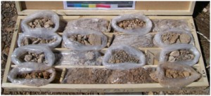
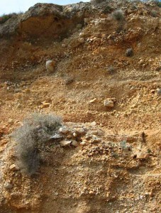
I will present an example where the lack of field work and understanding  of the situation can produce significant errors. In figure 1 the drilling core of cemented talus is presented. The material is classified as (GP) per ASTM 2487, SPT blow counts produce refusal of penetration and anyone evaluating
 this material from the office would assign the following material properties c’=0kPa and φ’>37ο, and they would design a slope with maximum inclination of about 28o in order to have a FS of about FS>1.4. The reality is that this slope is standing vertical without any stability problems as can be observed in figure 2.
It is very important for geotechnical engineers to have a real understanding of field conditions.
